|
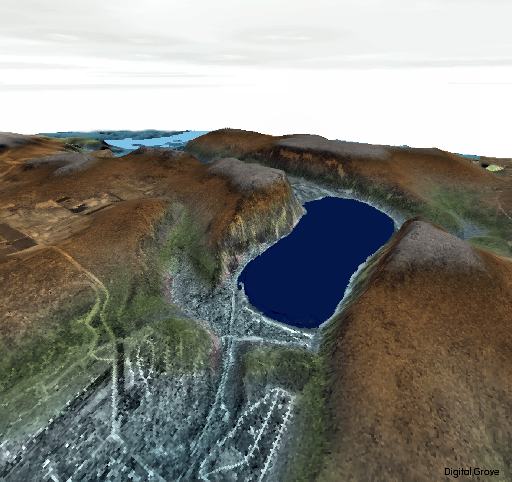
3D visualization
of Wisconsin's Devil's Lake State Park, made with Manifold System
5. The image combines a USGS DEM, colored for height, with a transparent
digital orthophoto overlay. Manifold can add sky, elevation-based
water, fog and other effects as shown here. Realistic as
the image seems, keep in mind it is not a photograph but a 3D
computer-generated elevation map!
This southeast facing view helps illustrate
how Devil's Lake was formed during the last Ice Age, which ended
about 10,000 years ago. Vast ice sheets up to two miles in height
advanced across Wisconsin. One lobe of the glacier reached its
furthest extent here, wrapping around the 500-foot bluff on the
left side of the present-day lake. The terminal moraine of rock
and gravel dumped by the glacier plugged what was once the channel
of an ancient river. A railroad corridor has been cut through
an arm of the moraine in the foreground. A similar moraine ridge
occurs on the other side of the bluff.
Devil's Lake formed in the depression between the two arms of
the glacial moraine.
You can see the path
of the ancient river channel as the gray elevation running through
the image. The present-day Wisconsin River ― about
200 feet lower than Devil's Lake ― can be seen as light
blue in the distance. Were it not for glacial dams, the Wisconsin
River would flow through this gorge today. In addition to
the end moraines, the old channel is filled in with over 100 feet
of glacial deposits.
Home
|