|
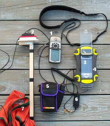
3. An iPAQ PDA (about $400)
running Vito SmartMap ($30)
for navigation and FS
Tally Meter ($0) for data collection.
TinyStocks Navio ($20) and Delorme XMap Handheld Pro ($50)
are a couple other GPS map/navigation programs that I like.
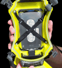
4. An Otterbox®
Armor 3600 rugged case ($100) and data cable port ($40) protect
the iPAQ from water, dust and bumps on rocks. One of the advantages
of the case is that it prevents the PDA serial/power connector
(which has light-duty spring clasps that break away with the least
lateral force) from being detached.
|
|
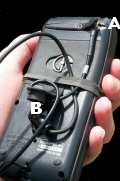
The
Otterbox is a well-engineered work of art. With the
back half removed, you can see the Velcro straps that
hold the PDA in place. There's also a foam pad, not
shown, to insert behind the PDA. The blue SD card
can be removed for data transfer without un-strapping
the PDA. The end cap has secure rubber gaskets that
have a firm grip on the cable so it can't be pulled
out. The standard Armor 3600 is deep enough to accommodate
an iPAQ battery-CF expansion pack.
|
|
 5.
A RoadPro
12-volt lead-acid rechargeable battery ($30). The battery
includes an AC adapter for recharging. The battery powers both
the PDA and GPS unit through the cable box (6). I've left both
the PDA and GPS unit run for eight hours with no lack of power.
The 12-volt battery constantly recharges the PDA battery. (Take
care to keep the battery fuse cap screwed on tightly or the power
supply will flicker, which could cause the GPS unit to turn off.)
The battery weighs about 2.5 pounds and fits in the back pocket
of the field vest. 5.
A RoadPro
12-volt lead-acid rechargeable battery ($30). The battery
includes an AC adapter for recharging. The battery powers both
the PDA and GPS unit through the cable box (6). I've left both
the PDA and GPS unit run for eight hours with no lack of power.
The 12-volt battery constantly recharges the PDA battery. (Take
care to keep the battery fuse cap screwed on tightly or the power
supply will flicker, which could cause the GPS unit to turn off.)
The battery weighs about 2.5 pounds and fits in the back pocket
of the field vest.
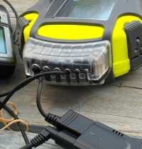
 6.
The data/power cable ($60) is from SupplyNet.
It connects the GPS unit to the PDA and has a cigarette-lighter
adapter that plugs into the 12-volt battery, providing power to
both the GPS and PDA. SupplyNet makes the cables for a wide variety
of GPS/PDA models. 6.
The data/power cable ($60) is from SupplyNet.
It connects the GPS unit to the PDA and has a cigarette-lighter
adapter that plugs into the 12-volt battery, providing power to
both the GPS and PDA. SupplyNet makes the cables for a wide variety
of GPS/PDA models.
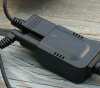
 7.
A field vest holds the GPS pole, GPS unit and 12-volt battery.
The wooden pole is attached to the inside back pouch of the vest
with three screws through the fabric into the wood. The metal
platform for the magnetic-mount GPS antenna is nothing but an
empty Altoids mint tin! The rubberized magnetic base on the antenna
is strong enough to stay in place even through a brush tangle.
(A custom
backpack with a telescopic GPS pole would be nicer, but more
expensive.) 7.
A field vest holds the GPS pole, GPS unit and 12-volt battery.
The wooden pole is attached to the inside back pouch of the vest
with three screws through the fabric into the wood. The metal
platform for the magnetic-mount GPS antenna is nothing but an
empty Altoids mint tin! The rubberized magnetic base on the antenna
is strong enough to stay in place even through a brush tangle.
(A custom
backpack with a telescopic GPS pole would be nicer, but more
expensive.)
The cables between the antenna,
GPS unit, battery and PDA are somewhat restraining and take getting
used to. Another option would be to use a wireless, pole-mounted
GPS unit. They are becoming more affordable. The Otterbox also
has an optional deep back to accommodate a battery expansion pack
for the iPAQ PDA.
Do you
need everything listed above? Not necessarily. In terms of
practical value, I'd assign these priorities:
1. A recreational grade
GPS unit. It's invaluable as a navigation tool and for recording
fairly accurate locations of plot data.
2. An external antenna for a
GPS unit (if yours accepts one). Not needing to constantly
orient the GPS receiver for optimal signal reception frees your
hands for other tasks. You can put the GPS receiver in a pocket
and just pull it out to record waypoints or to reference a position.
In the winter, you could put the GPS receiver inside your coat
to maintain battery power. (Cold weather significantly decreases
the life of NiMH and alkaline batteries. Lithium AA batteries,
which operate to -40°F, are another option for cold weather use
and extended battery life.)
3. A Pocket PC. A digital
data recorder can save significant time whether you use a simple,
free data program like FS Tally Meter or a sophisticated program
such as 2Dog or TCruise. A clipboard and paper are much cheaper,
however, and easier to operate in extreme weather.
4. A ruggedized PDA case.
You can use your PDA inside a Zip-Lock bag to keep it dry, but
an Otterbox or similar rugged case with a strap protects the PDA
from impacts and makes it easier handle. If you intend to connect
the PDA to an external battery or to a GPS receiver, a rugged
case can also help prevent cables from becoming disconnected.
5. An external power supply.
GPS receivers and data recorders require dependable batteries.
The batteries contained in the units might get you through the
day (or you can carry spare batteries). Having an external battery
with more than enough power for a full day is, however, an advantage.
The trade offs are the extra weight and cables.
6. Cables to connect
the GPS receiver, PDA and possibly an external power source.
A GPS and PDA work fine independently, but it's an added convenience
to view the GPS controls on the PDA and to automatically record
GPS coordinates with plot data. The more cables involved, however,
the more difficult it is to maneuver in the woods. Connecting
a GPS to a PDA may also make it undesirable to power-off the PDA
between plots, increasing the power demands for the PDA.
7. A GPS-enabled mapping program
for the PDA. Viewing locations on a GPS receiver screen is
adequate for basic navigation, but seeing your real-time location
displayed on an aerial photo, topo map or other specialized map
can be a fabulous advantage.
If you have $5,000 or so, you could
also buy a dedicated field data recorder from companies such as
Trimble or Leica that combine all of the above features in one
unit. Some dedicated field data recorders include additional features
such as a screen warmer and differential GPS corrections.
Home
/ About
|